
l'essence du sport
club de sport chic et exclusif alliant performance et design
à paris bruxelles et genève.
Chers Tous,
C’est avec une immense joie que nous vous confirmons que nous sommes ouverts.
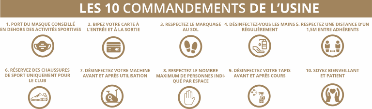
Vos clubs sont prêts à vous accueillir et nos engagements de propreté qui font notre réputation ont été renforcés au-delà même des directives des autorités afin de vous garantir une parfaite sécurité. Nous avons mis en place du nouveau mobilier ainsi qu’une signalétique nécessaire au respect des règles de distanciation. Un court film, que vous pourrez trouver dans les actualités, vous détaille ces mesures ainsi qu’une charte résumant les 10 points essentiels à suivre pour votre confort et notre bien-être à tous.
A l’entrée, de tous les espaces, est indiquée une capacité maximale, nous vous demanderons de la bienveillance à de rares moments. Les cours collectifs sont maintenus en majorité, les activités les plus intenses ont été adoucies, seul le Cycling est provisoirement suspendu dans l’attente des prochaines annonces prévues le 10 Juillet. Des cloisons sur-mesure, légères et lumineuses ont été mises en place entre les tapis de course et des elliptiques afin que vous puissiez profiter sans limitation et en toute sécurité du cardio-training. Autre privilège de l’Usine, la musculation guidée est totalement disponible compte-tenu de l’espace entre les machines.
En musculation libre, un nombre maximal de pratiquants est indiqué mais là encore, il correspond aux capacités habituelles. Enfin, pour votre confort, les cabines de douches
sont totalement accessibles.
Dans les vestiaires, nous avons condamné un casier sur deux pour plus de distance, seuls hammams et saunas restent portes closes, comme imposé par les autorités sanitaires.
A l’Usine, le numérus clausus et le nombre limité de membres ne nécessitent pas de réservation de votre part pour venir vous entraîner.
En effet, nous sommes en dessous des seuils exigés par les autorités.
Aujourd’hui nous en sommes fiers de ces choix et votre fidélité, depuis 15 ans, en est la preuve.
‘’C’est dans l’épreuve que la solidité des choses se révèle’’
L’Equipe de L’Usine
DÉCOUVRIR NOS CLUBS
OpEra
Le club historique, sur 3 niveaux et 1600m² d’espaces dans un décor unique. Ancienne huilerie, la bâtisse infuse les codes industriels avec l’alliage du métal, du bois et du béton combinés à un éclairage enveloppant et harmonieux. Studio de cycling, cours collectifs, espaces musculation et cardio-training et spa sont à votre disposition.
en semaine
7h - 23h
Week-end
9h - 20h
Jours Fériés
9h - 20h
Saint-lazare
2000m² sur deux niveaux au sein d’un monument historique, L’Usine Saint-Lazare plonge ses adhérents dans un décor hors du commun. Logé derrière de sublimes arcades du XIXème siècle de la Gare Saint-Lazare, L’Usine est entièrement baignée par la lumière naturelle avec une vue imprenable les 8e, 9e et 2e arrondissements.
en semaine
6h30 - 22h
Week-end
10h - 18h
Jours Fériés
10h - 18h
Beaubourg
Au coeur de Paris, rue Quincampoix, L’Usine Beaubourg intimiste, nous plonge dans un cadre exceptionnel de 750m² faisant écho à l’Histoire de la capitale et à son architecture médiévale. La particularité des lieux : la salle de cours collectifs, logée dans une ancienne cave à vin, organise ses classes sous une immense voûte avec murs et plafonds en pierre.
en semaine
7h - 23h
Week-end
9h - 20h
Jours Fériés
9h - 20h
Bruxelles
Au cœur de Bruxelles, dans le quartier chic et mode de Saint-Gilles, L’Usine vous invite, dans un décor spectaculaire façon Hollywood de 2400m², à découvrir une immense salle de cours de 250m² sous verrière, un grand studio de cycling, un studio de Yoga, une zone de training inondée de lumière naturelle et des vestiaires uniques.
en semaine
6h30 - 22h
Week-end
9h - 20h
Jours Fériés
9h - 20h
GenEVE
Sur 1200m², en plein cœur de Genève, à deux pas du Victoria Hall, L’Usine occupe un bâtiment magnifique inondé de lumière : une ancienne banque.
Lounge bar, studio pilates, cardio-training, musculation, cours collectifs, spa et vestiaires au confort unique.
en semaine
6h30 - 22h30
Week-end
9h - 20h
Jours Fériés
9h - 20h
Sélectionnez un club sur la carte pour afficher les coordonnées de contact
